Friday, November 28, 2008

California – Here We Come


Order "Jacob's Tails..." directly from the author

Check out the web site for the E-Book
http://www.firstepbooks.com/


Click on the pictures to enlarge them

We left Oregon in a flurry of rain, mist and fog – Surprise – but that did make for some incredible seas.

Our route was all mapped out – down Hwy 101 to Hwy 20, then across the hills to Hwy I-15 at Williams, California. Our first mistake was listening to the gal who ran a coffee shop we stopped at.

“Oh, don’t do that,” she told us, “that’s a terrible road across. Take 299 across to Redding – it’s a lot better road – four lanes most of the way.”

We’re still not sure if she was confused, ON something, or thought it would be a good joke to play on these outsiders.

What a road! Not the four-lane she assured us of (it had the occasional third passing lane) – it twisted in and out and up and down through the Redwood trees; around the side of one mountain with a hairpin turn at the bottom that took us over to the next set of mountains only to wind up and down though the Redwoods over there and onto the next.

IF it hadn’t been so rainy AND if we hadn’t been in an RV AND if we had a sense of where we were going, I think it would have been a great trip BUT it was raining; we were in the RV AND we didn’t have clue where we were.

“Oh, I can make it in two and ½ hours in the car,” she told us. Well those two hours took us around five!

We finally came out at Highway I-5 near Redding. Even though Interstate highways are not my favourites, it was a nice to find the BIG straight highway with all the trucks and cars whizzing by.


Love the coast: don’t like the never-ending rain. Now we were out of the rains and in a completely different terrain. The hills (mountains, they call them) and fields were the muted colours of fall that held notice that winter was not far away. The road wondered along fields, orchards and vineyards and through rolling, rounded hills dotted with clusters of green trees and shrubs – mostly oak, I found out later.


At first I thought the mist was fog, but then realized that it wasn’t a mist, it was a haze generated by the smog sitting over the entire San Joaquin Valley.


Welcome to California!


The Oak Trees here are a lot different than the ones we saw in Alabama (the Live Oak) but still fascinating. They dot the fields and clump in bunches throughout the hills.


My research into the Oak Trees of California actually describes them as Tree Oak and Shrub Oak. They site about nine different tree species, twelve different shrub species and various hybrid species.


They are incredibly prolific, given the right climate. One thing that distinguishes oak from other trees is that they produce acorns. The Natives used the acorns for food. They would make a kind of a mush and use it in breads and puddings and such. It is said to be very nutritional and is cited as being the foundation for a long healthy life.

Once we hit the Park of the Sierras (an Escapee Park just south of Yosemite National Park, about 30 miles north of Fresno), we were ready to slow down for a while. We had some problems with the brake system in the car and arrived there with a dead car battery. It was nice to find folks who were willing to help.

What a great place to take a break. Unlike most RV Parks that resemble parking lots with the occasional tree, POS (as they call it) is built on the side of a hill and the sites are scattered in and amongst the trees. The roads wind and climb throughout the whole area and each site is its own unique landscaped alcove.


We only spent a week or so in this part of California and leaving wasn’t easy either. We took the BIG Highway heading towards Arizona, only to be confronted with a major traffic jam.


At the top of the hill we discovered a completely burnt-up motorhome on the side of the road. Now that was scary! It sure reminded us you how extra cautious you have to be. (It bothers me that there is no escape window in the bedroom and there should be!)

We did pull off a couple of times so I could get some pictures of the hundreds of wind mills that went on for miles along the ridge of the whole Tehachapi Valley.


Unlike our usual routine, we drove well into the night. Along the way, we stopped at Needles, CA for a bite to eat only to realize it was the same restaurant we stopped at with Ann & Eldon (a couple we travelled with) eight years ago.


The desert was calling and we arrived at the Avi Casino (right at the corner of California, Arizona and Nevada) both being very tired.


It’s funny how you can get so tired even though you aren’t actually driving.


Sunday, November 9, 2008

The Coast of Oregon is incredible!

Order "Jacob's Tails..." directly from the author

Check out the web site for the E-Book
http://www.firstepbooks.com/

Click on the pictures to enlarge them

The Coast of Oregon is incredible! It's so different from the East Coast. The beaches are so-o-o big - they seem to go on for miles and miles and miles. The smell and the sounds are indescribable.


Our first stop, the South Beach State Park is just a couple miles across the bridge, south of Newport. Newport, itself, turned out to be a great little coastal town – quaint and didn’t seem to be quite as ‘developed’ as many of the other town we visited.

Mo's Diner - Newport

Wharf-Newport

The town waterfront area has retained much of its historic atmosphere and is still vibrant with the fishing boats moving in and out of the harbour with their catches.

Sea Lions-Newport

The wharfs are covered with fishers selling their catches and sea lions lazing around just waiting for leftovers.

The beaches – what can I say, except they are mesmerizing –the motion, the sound and the smell of the ocean – the waves slapping up around the rocks and onto the sand – each wave taking a different path, landing at a different spot and then disappearing out into the endless grey water.


Whaleshead Beach

One particular beach (Whaleshead Beach) had extra intrigue. All the way down the path there was an overwhelming odour of liquorice (or anise). The plants along the side of the path looked like dill.

The single soul on the beach was an older gentleman wearing hip-waders. He was flying a remote controlled model airplane. I asked him about the aroma along the path.

He told me that this particular area was very important to the Natives because of the plants (he told me that it was fennel). They would camp on the shore above, fish and gather clams and mussels. They used the fennel for medicine and flavouring. As an aside, he told me that the varioustribes were all gathered up, even though they didn’t get along with each other, and shipped off to one reservation further north. Then the white people wondered why they didn’t get along.

In some places, the coast becomes very rugged but again interspersed with continuous sand with the occasional footprint or flock of birds.


Cooks Chasm
We've visited a couple of Lighthouses (Do you know there are nine lighthouses in Oregon). On the way out to the Lighthouse at Cape Blanco (south of Bandon) we stopped to tour a restored Mansion and then sat and watch them harvest cranberries along the side of the road. But we found ourselves constantly drawn to the surf and sounds of the ocean.

Cape Blanco Lighthouse CranberryHarvest Coquille River Lighthouse

As we travelled further south, more and more rock formations seemed to erupt out of the water – some so small, you could barely sit on them and others, huge rugged islands with crevices and crannies created by eons of water crashing against the rocks. Each area is spectacular and unique.

And the waves: some soft and gentle, glide onto the beach only to retreat again into the vast endless expanse of grey-blue and blend into the horizon. Other waves violently attack the rocks and explode upwards. The waves recoil. The rocks remain unscathed by the ferocious impact. Again the waves launch their attack and again the rocks emerge unharmed. Over and over again the dance continues. Each time the waves withdraw into the vast open waters so they can try it again. Again the waves are on the move: some come crashing in while others gently lick the outer edges of the rocks. Each time the movements are different and yet each time the rocks reappear unaffected.


The first real fog we encountered was travelling along the coast from Bandon to Brookings. Fog is so eerie – its like the world is trying to hide something and you will never know what it is.

It changed from a light, pleasant mist to a heavy haze that totally obscured everything around. The fog was so thick that the centre line of the highway was hardly visible, then a few miles further down the road the bank of grey cloud drifted out over the water and blue skies and sunlight emerged just long enough to again be awestruck by the power and magnificence of nature.

It was fascinating to sit at our campsite about 200 feet from the water and watch the mist drift in and intermingle with the Redwoods until the fog totally engulfed the entire forest around us.

Our itinerary tends to depend on the weather and when the forecasts all pointed towards beginning of the eminent ‘costal rains’ with no end in sight, we concluded that it was time to move on – further inland to search out the sun.

California, here we come.

Saturday, October 25, 2008

The ‘Flatlanders’ head for the Oregon coast


We were absolutely chomping at the bit to get going again and ended up leaving a couple of days before we had planned realizing that we didn’t have to wait for our Travel Medical Insurance to kick in cuz we were still going to be in Canada for a couple of days – da!

First night was in Cranbrook, BC to visit RV friends! Oh, my God, was it ever cold and we were not plugged in so we cuddled – that can only keep you warm for so long, so we headed south!

We got to Coeur d’Alene the next night and went on a telephone hunting expedition. We thought we had the activation situation all solved after the problems last year – BUT – guess what – we still ended up talking to Bogotá, Columbia, Belize City and Guyana (S. America) before we finally got that straightened out. We are now officially connected with Idaho and Calgary phone numbers.

As is our routine – we go fast and furiously for the first few hundred miles and then take a few days to get adjusted and figure out where we want to go next and what we forgot to pack. This time we ended up at an Oregon State Park (Deschute) in the Columbia River Gorge where the Deschute and the Columbia rivers converge.


Oregon has fantastic State Parks! They’re well laid out and well kept.

Most of the sites have at least electric and water and they are

reasonably priced (this one was $12/night) – couldn’t ask for much better.


The Dalles was the nearest community of any size and Mt Hood shadows a multitude of markets, orchards, vine-yards and wineries that are scattered throughout the whole area.


We toured what they called the “Fruit-Loop” and ended up at a community Fair at Parkdale that highlighted local crafts as well as a working train that still runs daily from Hood River to Parkdale.


When you take the time to ‘visit’ with fellow RV’er, you usually learn something and always get advice on where to go next and how to get there – and so it was! By the time we left the Columbia Gorge area, we were heading for the coast and South Beach State Park just south of Newport, Oregon and even knew how we were going to get there.

Saturday, August 30, 2008

Cabin-fever – Itchy Feet


Jacob's Tails ... (Back-to-the-Land)"
can be ordered directly from the author
Check out the web site for the E-Book
Whatever you want to call it . . . we really needed to get away.

Someone suggested that there was a nice little campground in the Elk Valley (in BC) at Sparwood.
Okay – close enough that it was within our fuel budget; an area we had flashed through so many times but never explored; a viable solution.

Elk Valley became our get-away destination.
It took us almost two weeks to get a site for a whole week (so unlike us to even make a reservation) and we had absolutely no idea what we were going to do once we got there (so like us to not plan).

Sparwood didn’t even exist when I was growing up in Lethbridge (or so I thought). I remember Michel, Natal, and even New Michel, but Sparwood? I had never heard of it!! And what I remembered about Michel and Natal was the charcoal coloured houses that sat along the highway and always looked very old, downtrodden and dull. In my mind’s eye, I pictured everyone who came from there as always covered with a fine grey dust no matter how many baths or showers they took.

To me, coal mines were tunnels drilled deep into the side of a hill. Each morning a whole horde of men went into the hole and came out eight hours later even greyer than when they went in. I thought of them as hard working and hard playing men who didn’t live very long because of all the accidents and disease that came along with coal mining.


This venture surprised me and definitely changed my attitude.


I guess I wasn’t the only one who thought this way because in 1967, the Provincial Government of British Columbia actually moved Michel and Natal (people and everything else they could move) to Sparwood, a very small place a few miles to the west. Word has it that the powers that be felt that the Michel/Natal area was not a welcoming site for travellers coming into BC from Alberta, so they created this ideal community to greet the ever increasing hordes of tourists they expected to come to experience Beautiful British Columbia.


Sparwood did exist before this but only as a supplier of tall straight lodge-pole pines that ship-builders on the west coast needed for the masts for their ships – thus the name Sparwood!

Click on the pictures to enlarge them


Getting to the Elk Valley

The only highway from Lethbridge to Sparwood is through the Crowsnest Pass. The highway seems to ride above huge mounds of boulders (some as big as houses) on both sides of the road - remnants of the early 20th century Frank Slide disaster – and then through a series of small communities.


Just like the BC Government did in the Elk Valley, the Alberta Government cleaned up and combined all the small coal communities through the Pass – Coleman, Bellevue, Blairmore, Hillcrest, and Frank. I’m sure this is where I got my ideas about coal mining only being underground (reinforced by the time we spent in Cape Breton). There are no mines anymore but they have preserved a sense of their coal mining history. The Crowsnest Lake is the first sign of the wilderness that await you on the other side of the Alberta/BC border.


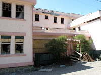
The only visible remnant of Michel/Natal is the old Michel Hotel that sits deserted on the eastern edge of the town. We stopped in there one time when the dining room was open and they were trying to fix it up but finally gave up a couple of years ago. It has disintegrated since then and now the pink stucco exterior is totally sun-faded and most of the windows are either broken or boarded up – a dying reminder of the abandoned communities.


Elk Valley

As close as I can figure it, the Elk Valley must be about 100 miles long from the US border almost to Kananaskis Country in Alberta as it sits between the Alberta border and the Kootenay Mountain Range.


Sparwood, the official eastern entrance to the Elk Valley, is bright and new but still dominated by the coal mining industry (even though they’re trying to build up the tourist trade). The Biggest Dump Truck in the World is showcased on the grass outside the Tourist Information Centre.


The only Campground (Mountain Shadows) is nice but limited in size. It is built amongst the lodge-pole pines and gives campers a sense of the rough country.


We did two coal mine tours on this trip. The Elkview operation out of Sparwood was okay, but the smaller Greenhills tour was spectacular – it could be because the guides at Greenhills explained so much more about the area and the operations.


The first thing that astonished me was just how massively huge the open pit quarries are and then how huge the equipment is.


When we saw some deer drinking our of a puddle way below where we stopped, it gave me a chance to see how the 20xzoom worked on the new camera – not bad, eh?


On the Greenhills Operations tour, as we travelled up to an altitude of almost 7000 feet, we got incredible views of the surrounding mountains and wildlife as well as the working of the mine and the huge equipment.

We got a lot closer at Greenhills – talk about feeling like a tiny little ant!!


The mines weren’t the only trips we took – we met Alan & Ina (folks we met in Nanaimo a couple of years ago) in Fernie (the town on the other side of the Valley) and headed up a steep winding wilderness road up to the mountains behind Fernie up to the Island Lake Lodge.

During the winter, the road is impassable but, apparently, the skiing in magnificent. The Lodge picks skiers up in Fernie with the Cat and takes them ‘anywhere you can see up there’ explained the fellow we talked to. They call it Catskiing and they use these huge machines on tracks to take people up to wilderness ski.


In the summer, it becomes a high end retreat complete with a Spa, an incredible view and wilderness hiking trails.


You know, when we spend so much time exploring places away from home, we forget how incredible it is right next door.